Tour De France 2017 — Stage 10

Technical sheet

55007434
Creation
Last update
  • Road biking
    Activity: Road biking
  • ↔
    Distance: 176.45 km
  • ◔
    Author’s time: Duration unknown 
  • ▲
    Difficulty: Not specified

  • ⚐
    Return to departure point: No
  • ↗
    Vertical gain: + 901 m
  • ↘
    Vertical drop: - 970 m

  • ▲
    Highest point: 268 m
  • ▼
    Lowest point: 19 m
  • ⚐ Country: France
  • ⚐
    Area: Périgord
  • ⚐ District: Boulazac (24750)
  • ⚑
    Start: N 45.16806° / E 0.769558°
  • ⚑
    End: N 44.84341° / E 0.49985°
  • ❏
    IGN map(s): Ref. 1835E, 1835O, 1836E, 1836O, 1935E, 1935O, 1936ET, 1936O, 1937E, 2035O

  • ◶
    Path proportions: Not specified

  • Today’s forecast: … Loading…

Description

Start the plot by indicating the starting point. If you know the exact car parking situation, please explain how to park.
If we can access the starting point with public transports, please explain the lines to use and share any useful informations.

(S) From here, describe the instructions to follow from the starting point.

Add waypoints by clicking on the map.

The plot has to end by the location where the walk finishes. If it is a loop please write (S/E) at the end of the description. If it is a one way route write (E).
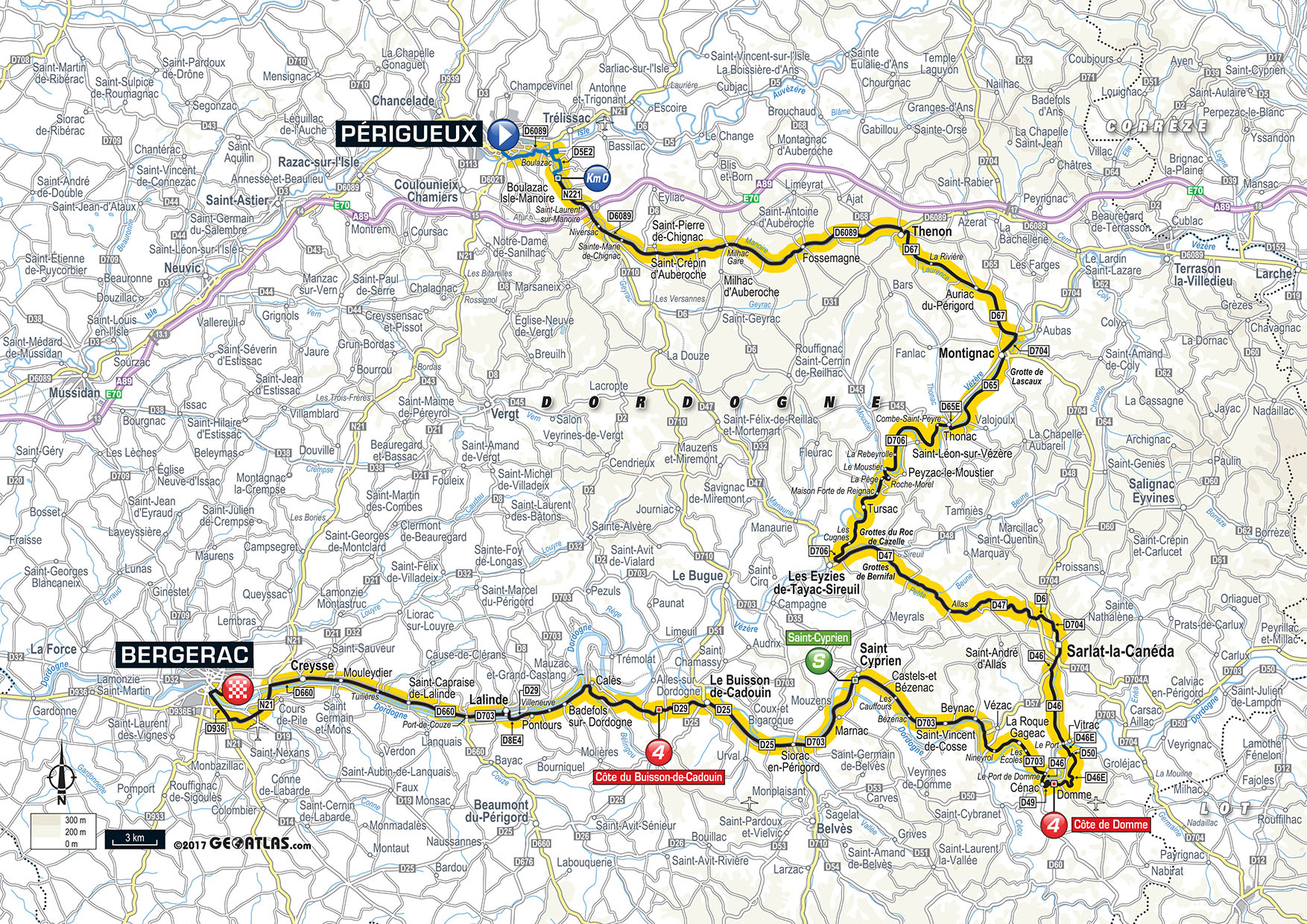
Waypoints

  1. S : km 0 - alt. 99 m
  2. 1 : km 0 - alt. 99 m - Head south on Avenue Emile Zola
  3. 2 : km 1.03 - alt. 104 m - Continue onto Route de Lyon
  4. 3 : km 1.95 - alt. 109 m - At the roundabout, take the 2nd exit
  5. 4 : km 2.78 - alt. 106 m - At the roundabout, take the 2nd exit onto D6089
  6. 5 : km 3.99 - alt. 109 m - At the roundabout, take the 3rd exit and stay on D6089
  7. 6 : km 4.39 - alt. 113 m - Head south-east on D6089
  8. 7 : km 5.49 - alt. 113 m - At the roundabout, take the 1st exit and stay on D6089
  9. 8 : km 6.29 - alt. 119 m - Head east on D6089
  10. 9 : km 8.85 - alt. 131 m - Head east on D6089
  11. 10 : km 11.6 - alt. 146 m - Head north-east on D6089
  12. 11 : km 14.18 - alt. 160 m - Head east on D6089
  13. 12 : km 17.3 - alt. 179 m - Head south-east on D6089
  14. 13 : km 19.89 - alt. 198 m - Head north-east on D6089
  15. 14 : km 22.32 - alt. 224 m - Head north-east on D6089
  16. 15 : km 24.79 - alt. 255 m - Head north-east on D6089
  17. 16 : km 27.65 - alt. 266 m - Turn right onto Av. de la IV République/D67
  18. 17 : km 29.03 - alt. 204 m - Head south on D67
  19. 18 : km 35.55 - alt. 115 m - Head east on D67 towards D65
  20. 19 : km 40.1 - alt. 81 m - At the roundabout, take the 1st exit onto Avenue du Chambon/D704
  21. 20 : km 40.31 - alt. 79 m - Head south on Avenue du Chambon/D704 towards Chemin de Saint-Pierre
  22. 21 : km 41.05 - alt. 83 m - At the roundabout, continue straight onto Rue de Juillet/D704E2
  23. 22 : km 41.65 - alt. 77 m - Turn left onto D704E2
  24. 23 : km 41.74 - alt. 74 m - Turn right onto Avenue Aristide Briand/D65
  25. 24 : km 42.06 - alt. 73 m - Head south on Avenue Aristide Briand/D65 towards Chemin de Gouny
  26. 25 : km 48.32 - alt. 79 m - Head west on D65 towards D65E
  27. 26 : km 48.63 - alt. 75 m - Turn right onto D65E
  28. 27 : km 48.96 - alt. 72 m - At the roundabout, take the 3rd exit onto D706
  29. 28 : km 49.52 - alt. 75 m - Head south-west on D706
  30. 29 : km 53.12 - alt. 79 m - Head west on D706
  31. 30 : km 57.48 - alt. 69 m - Head north-west on D706 towards D6
  32. 31 : km 59.78 - alt. 66 m - Head south-west on D706
  33. 32 : km 63.74 - alt. 141 m - Head south on D706
  34. 33 : km 66.89 - alt. 75 m - Head south-west on Avenue du Moustier/D706 towards Rue du Moulin
  35. 34 : km 67.02 - alt. 70 m - At the roundabout, take the 2nd exit
  36. 35 : km 67.09 - alt. 71 m - Continue onto Avenue de la Forge/D47
  37. 36 : km 70.76 - alt. 88 m - Head south-east on D47
  38. 37 : km 83.95 - alt. 261 m - Head south-east on Avenue du Colonel Kauffmann/D47 towards D6
  39. 38 : km 84.79 - alt. 239 m - At the roundabout, take the 4th exit onto Avenue du Colonel Kauffmann/D6
  40. 39 : km 86.37 - alt. 165 m - Slight right onto Avenue de Selves/D704
  41. 40 : km 87.83 - alt. 135 m - Continue straight onto Rue Emile Fauré/D704
  42. 41 : km 87.97 - alt. 133 m - Head south on Rue de Cahors/D704 towards Rue de l'Abbé Surgier
  43. 42 : km 88.77 - alt. 126 m - At the roundabout, take the 1st exit onto Avenue de la Dordogne/D46
  44. 43 : km 89.05 - alt. 134 m - At the roundabout, take the 2nd exit and stay on Avenue de la Dordogne/D46
  45. 44 : km 89.67 - alt. 126 m - Head south-west on Avenue de la Dordogne/D46
  46. 45 : km 89.81 - alt. 120 m - At the roundabout, take the 3rd exit onto D46
  47. 46 : km 94.84 - alt. 89 m - Head south-east on D46 towards D55
  48. 47 : km 95.3 - alt. 76 m - Continue onto D703
  49. 48 : km 95.37 - alt. 78 m - At the roundabout, take the 2nd exit onto D46E3
  50. 49 : km 96.17 - alt. 79 m - Head south-east on D46E3 towards D50
  51. 50 : km 96.35 - alt. 87 m - Turn left onto D50
  52. 51 : km 96.42 - alt. 87 m - Turn right onto D46E3
  53. 52 : km 97.56 - alt. 103 m - Head south-west on D46E3
  54. 53 : km 98.58 - alt. 135 m - Head east on D46E3
  55. 54 : km 100 - alt. 174 m - Head west on D46E3
  56. 55 : km 100.29 - alt. 175 m - Continue straight
  57. 56 : km 100.59 - alt. 183 m - Head west
  58. 57 : km 100.73 - alt. 194 m - Turn right towards Rue Geoffroy de Vivans
  59. 58 : km 100.8 - alt. 203 m - Turn left onto Rue Geoffroy de Vivans
  60. 59 : km 100.91 - alt. 205 m - Continue onto Rue René Carmille
  61. 60 : km 100.94 - alt. 203 m - Head west on Rue René Carmille towards Rue de la Monnaie
  62. 61 : km 100.96 - alt. 202 m - Continue onto Rue de la Chapellenie
  63. 62 : km 101.04 - alt. 199 m - Slight left at Rue Guibert de Domme
  64. 63 : km 101.07 - alt. 195 m - Head south-west towards Rue de l'Equirol
  65. 64 : km 101.09 - alt. 191 m - Turn left onto Rue de l'Equirol
  66. 65 : km 101.13 - alt. 189 m - Head south-east on Rue de l'Equirol towards Rue de la Porte Delbos
  67. 66 : km 101.15 - alt. 189 m - Turn right at Rue de la Porte Delbos
  68. 67 : km 101.17 - alt. 187 m - Head south-west towards D49
  69. 68 : km 101.19 - alt. 184 m - Turn right onto D49
  70. 69 : km 101.26 - alt. 182 m - Head west on D49
  71. 70 : km 101.48 - alt. 173 m - Head west on D49
  72. 71 : km 102.16 - alt. 140 m - Head north-east on D49 towards D50
  73. 72 : km 103.14 - alt. 74 m - Turn right onto D46
  74. 73 : km 103.49 - alt. 71 m - Head north on D46 towards D703
  75. 74 : km 103.89 - alt. 74 m - Turn left onto D703 (signs for La Roque-Gageac/Beynac)
  76. 75 : km 104.16 - alt. 75 m - Head west on D703
  77. 76 : km 109.63 - alt. 74 m - Head north on D703 towards D49
  78. 77 : km 110.26 - alt. 67 m - Turn left to stay on D703
  79. 78 : km 113.14 - alt. 68 m - Head west on D703
  80. 79 : km 118.76 - alt. 71 m - Head north-west on D703
  81. 80 : km 120.23 - alt. 62 m - Head north-west on D703 towards D49
  82. 81 : km 124.98 - alt. 66 m - Head south-west on D703
  83. 82 : km 127.89 - alt. 60 m - At the roundabout, take the 2nd exit onto Voie de la Vallée/D25
  84. 83 : km 128.4 - alt. 59 m - Head west on Voie de la Vallée/D25 towards Voie de la Vallée/D25
  85. 84 : km 134.83 - alt. 62 m - Head west on Avenue des Sycomores/D25 towards Rue de la Boétie
  86. 85 : km 135.17 - alt. 63 m - Slight right onto Avenue d'Aquitaine/D29E2
  87. 86 : km 135.97 - alt. 63 m - At the roundabout, take the 2nd exit onto D29
  88. 87 : km 143.65 - alt. 70 m - Continue onto D28
  89. 88 : km 143.84 - alt. 60 m - Head north-west on D28
  90. 89 : km 145.01 - alt. 46 m - Continue onto D29
  91. 90 : km 150.49 - alt. 41 m - Continue onto D8E4
  92. 91 : km 151.42 - alt. 43 m - Turn right onto Place du 8 Mai 1945/D703 (signs for Mauzac/Ste Alvère)
  93. 92 : km 151.44 - alt. 43 m - Turn left onto D8E3 (signs for Bergerac/Périgueux/Beaumont/Couze)
  94. 93 : km 152.09 - alt. 41 m - Slight right onto Avenue Paul Langevin/D703
  95. 94 : km 153.14 - alt. 41 m - Head west on Avenue Jean Moulin/D703
  96. 95 : km 154.61 - alt. 42 m - Continue onto Route de Bergerac/D660
  97. 96 : km 160.88 - alt. 38 m - Head west on Avenue du Barrage/D660 towards Route du Maine
  98. 97 : km 162.05 - alt. 38 m - At the roundabout, take the 1st exit onto Avenue de la Gravière/D660
  99. 98 : km 166.48 - alt. 33 m - Head west on Avenue de la Roque/D660 towards Route des Rigoux
  100. 99 : km 168.33 - alt. 34 m - At the roundabout, take the 2nd exit and stay on Avenue de la Roque/D660
  101. 100 : km 168.53 - alt. 35 m - At the roundabout, take the 3rd exit onto N21
  102. 101 : km 168.83 - alt. 34 m - Head south on N21
  103. 102 : km 170.4 - alt. 42 m - Head south-west on N21
  104. 103 : km 172.48 - alt. 47 m - Head north-west on N21
  105. 104 : km 172.82 - alt. 46 m - At the roundabout, take the 1st exit onto Avenue Paul Painlevé
  106. 105 : km 173.66 - alt. 32 m - Head north-west on Avenue Paul Painlevé
  107. 106 : km 175.1 - alt. 30 m - At the roundabout, take the 1st exit onto Boulevard Louis Pimont
  108. 107 : km 175.47 - alt. 25 m - Head north-east on Boulevard Louis Pimont
  109. 108 : km 175.54 - alt. 30 m - At the roundabout, take the 1st exit onto Rue Clairat/D660
  110. 109 : km 176.06 - alt. 31 m - Head east on Rue Emile Zola/D660 towards Rue Albert Thomas
  111. 110 : km 176.23 - alt. 30 m - Head east on Rue Emile Zola/D660 towards Rue Nungesser et Coli
  112. E : km 176.45 - alt. 31 m

Useful Information

Always stay careful and alert while following a route. Visorando and the author of this walk cannot be held responsible in the event of an accident during this route.

The GPS track and description are the property of the author.

Loading…